Property Information Report
Wyatt Avenue
Salford, M5
Description
An immaculately presented, three bedroom, semi-detached family home within WALKING DISTANCE OF SALFORD QUAYS & MEDIA CITY! Boasting a huge bathroom, complete with ‘his and hers’ sinks, a beautifully maintained decked garden to the rear that benefits from the sun, and a driveway for off-road parking!
Situated in a popular location, the property is within easy access of amenities, including a range of bars, shops and restaurants found in Salford Quays, Media City and Manchester City Centre. The property is close to excellent transport links throughout Manchester, and local schooling too.
As you enter the property you head into the modern kitchen diner, which leads to the middle hallway. From here, you will find a storage cupboard, which can be turned back into a downstairs W/C, and a spacious lounge with patio doors to the rear.
Upstairs, there are three well-proportioned bedrooms and a huge, modern three-piece family bathroom, complete with ‘his and hers’ sinks. To the front and rear there are brick-built outbuildings which provide further storage. To the front of the property there is a driveway, which provides off-road parking. To the rear, there is a beautifully maintained decked garden which is a great social space, and benefits from the sun.
Viewing is highly recommended, get in touch to secure your viewing today!
Key Facts
No lease data available
About Us

About Us
Passionate about what we do. Here to serve the people of Salford and Greater Manchester and dedicated to helping you find your perfect home. Meet the multi-award winning team of property professionals at Hills.
Generate a full report on your own property including an instant estimated valuation.
Title Plan
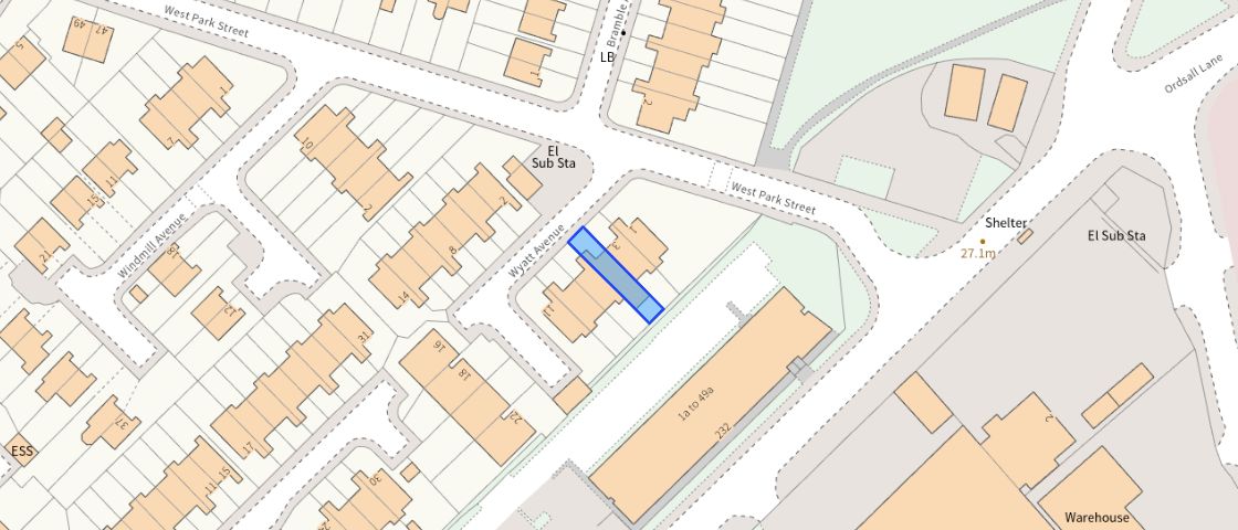 Contains OS data © Crown copyright 2025
Title Information
Details provided by the Land Registry
- Title Number
- MAN78821
- Plot Size
- 0.03 acres (120 sq metres)
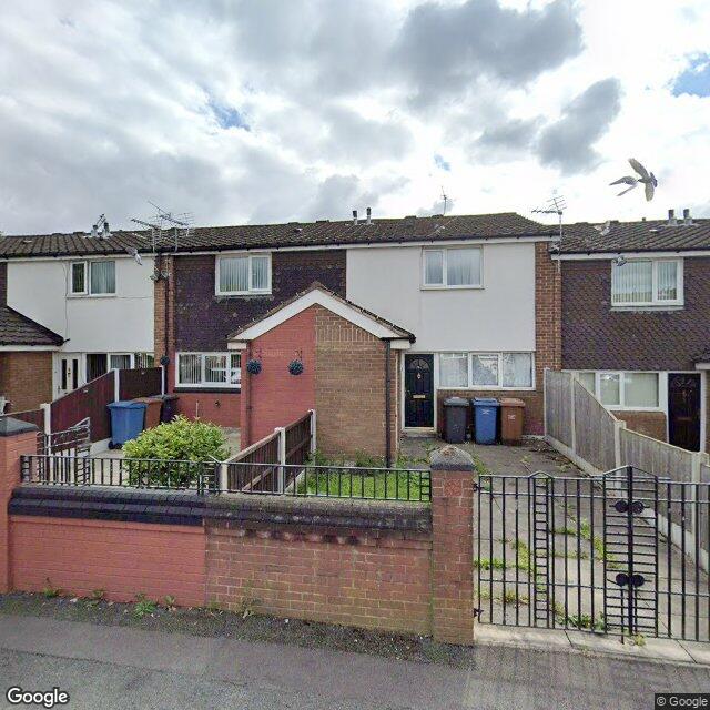
Street View
Videos & Virtual Tours
EPC
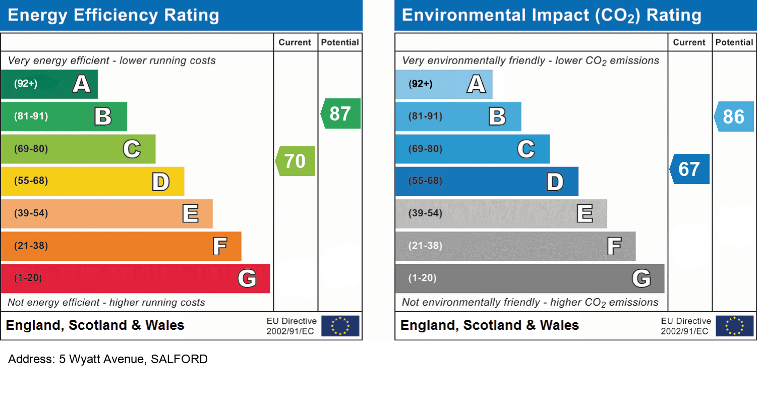
EPC Information
Details taken from the EPC register
- Date
- 2024-08-02
- Valid Until
- 2034-08-01
- Energy Efficiency - Current
- 70
- Energy Efficiency - Potential
- 87
- Environmental Impact - Current
- 67
- Environmental Impact - Potential
- 86
Hills Salfords Estate Agents
Schools
| Name | Type | Postcode | Distance | Rating |
|---|---|---|---|---|
| Primrose Hill Primary School and Children's Centre | Nursery, Primary | M5 3PJ | 0.55 km | Good |
| St Joseph's RC Primary School | Nursery, Primary | M5 3JP | 0.65 km | Good |
| Oasis Academy MediaCityUK | Secondary | M50 3UQ | 0.73 km | Good |
| Old Trafford Community Academy | Nursery, Primary | M15 4FL | 0.93 km | Not rated |
| Thompsons Academy trading as Navigators | Special | M50 3XW | 1.10 km | Not rated |
Transport
Bus Stops & Stations
Details provided by Department for Transport
| Name | Distance |
|---|---|
| West Park St, Ordsall Lane | 99 metres |
| Ordsall Lane | 0.14 km |
| St Clement'S Drive | 0.16 km |
| Welcome Inn, Robert Hall Street | 0.17 km |
| Robert Hall Street | 0.27 km |
Train Stations
Details provided by Department for Transport
| Name | Distance |
|---|---|
| Deansgate Rail Station | 1.39 km |
| Salford Crescent Rail Station | 1.57 km |
| Manchester United Rail Station | 1.64 km |
| Salford Central Rail Station | 1.64 km |
| Manchester United Fc Rail Station | 1.66 km |
Nearest Motorway
Details provided by Department for Transport
| Name | Distance |
|---|---|
| M602 | 1.15 km |
Tram and Metro Stations
Details provided by Department for Transport
| Name | Distance |
|---|---|
| Cornbrook (Manchester Metrolink) | 0.39 km |
| Salford Quays (Manchester Metrolink) | 0.84 km |
| Exchange Quay (Manchester Metrolink) | 0.89 km |
| Pomona (Manchester Metrolink) | 0.91 km |
| Anchorage (Manchester Metrolink) | 0.96 km |
Coverage
- Average Broadband Speed:
-
14mb Basic
-
10000mb Ultrafast
-
10000mb Overall
- Mobile Coverage:
-
EEOkay
-
O2Good
-
ThreePoor
-
VodafoneOkay
Important Notice - This report is intended for general informational purposes only and should act only as a guide. The report is produced automatically on behalf of Hills - Hills by Street Insights, a product of Street Systems Ltd. Street Systems maintains and aggregates data from multiple public data sources and whilst every effort is made to keep information up to date and accurate, we make no representations or warranties of any kind about the accuracy, reliability or completeness of the information contained within this report for any purpose. Any reliance you place on the data contained within this report is strictly at your own risk. In no event will Hills - Hills or Street Systems Ltd be liable for any loss or damage including without limitation, indirect or consequential loss or damage, or any loss or damage whatsoever arising from loss of data or profits arising out of, or in connection with, the use of this report.
This report contains public sector information licensed under the Open Government License v3.0
Transaction data and HPI data is produced by HM Land Registry. Crown copyright and database rights 2025