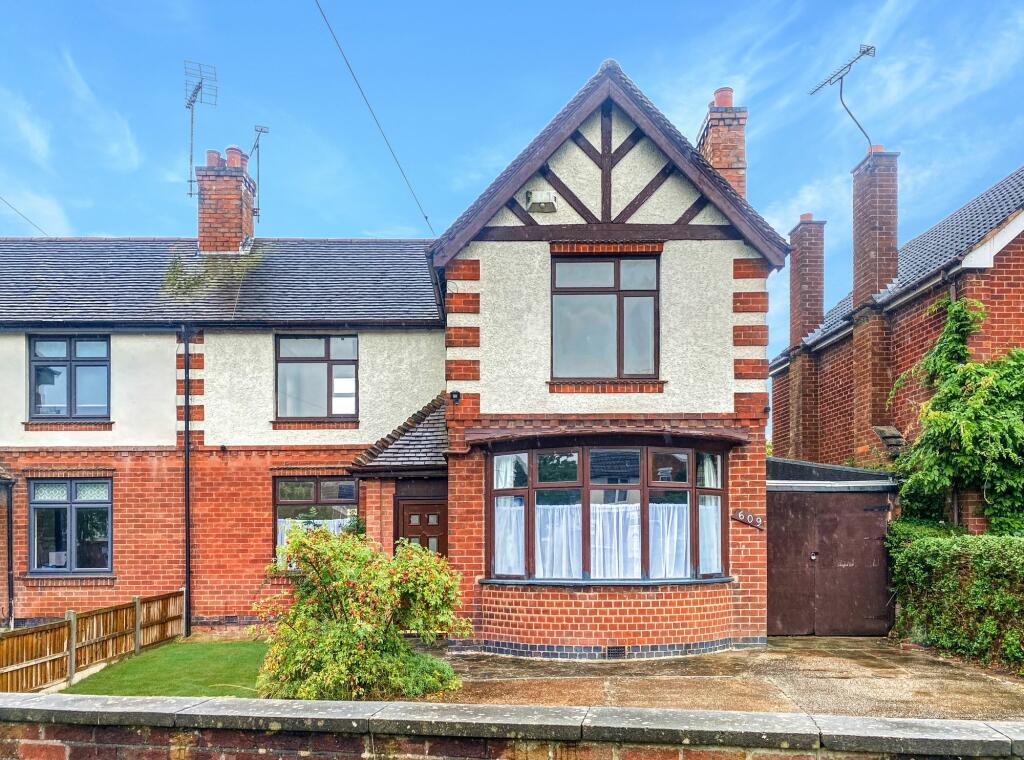
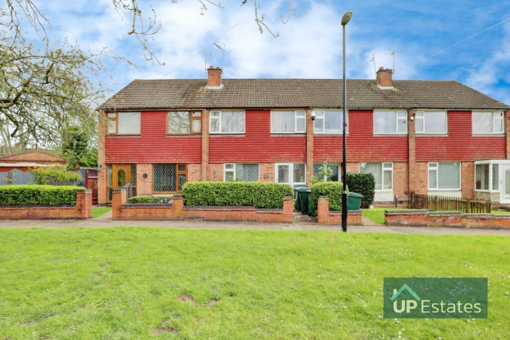
Property Information Report
Henley Road
Coventry, CV2
Last Sold - Sep, 2014

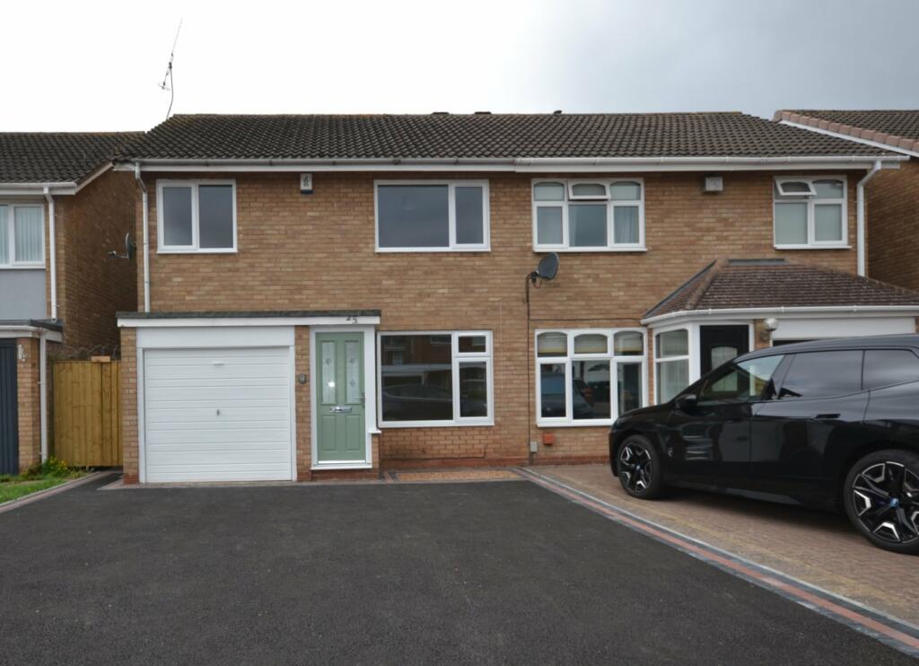
Description
A handsome and very spacious semi detached family home set in extremely large gardens and for sale with no upward chain.
Enclosed porch, entrance hallway with block flooring, front living room with wide double glazed bay and feature slate fireplace. Rear living room with french doors to a spacious conservatory with patio doors to garden. Large dining kitchen with a range of matching units incorporating a built in oven, gas hob and microwave. Front bedroom with very deep built in wardrobes and ensuite shower room, two further bedrooms and family bathroom with white suite.
Set behind a walled front garden with direct driveway to side carport and particularly large rear garden with patio and decking areas and extensive lawns.
Key Facts
Title Plan
 Contains OS data © Crown copyright 2024
Title Information
Details provided by the Land Registry
- Title Number
- WM246907
- Plot Size
- 0.20 acres (814 sq metres)
Street View
House Prices in Coventry
Last 12 months
-
Average Price Change
£10,521
Increased by 5%
-
Semi-Detached Price Change
£14,707
Increased by 6%
Average House Prices
Last 12 months for all property types.
Since - June 2019
-
Average Price Change
£41,626
Increased by 22%
-
Semi-Detached Price Change
£51,792
Increased by 23%
Average House Prices
Since 2019 for all property types
EPC

EPC Information
Details taken from the EPC register
- Date
- 2018-12-04
- Valid Until
- 2028-12-03
- Energy Efficiency - Current
- 58
- Energy Efficiency - Potential
- 79
- Environmental Impact - Current
- 52
- Environmental Impact - Potential
- 74
Properties For Sale in the Area
Henley Road
Henley Road
62 metres away
Woodway Lane
74 metres away
Woodway Lane
0.13 km away
Newton Close
0.13 km away
Woodway Lane
0.18 km away
Properties To Let in the Area
Woodway Lane
0.16 km away
Pandora Road
0.24 km away
Lumsden Close
0.25 km away

Elizabeth Way
0.34 km away
Balmoral Close
0.43 km away
Blackshaw Drive
0.43 km away
Schools
| Name | Type | Postcode | Distance | Rating |
|---|---|---|---|---|
| SS Peter and Paul Catholic Primary School | Primary | CV2 2EF | 0.17 km | Good |
| Whittle Academy | Nursery, Primary | CV2 2LH | 0.44 km | Good |
| Walsgrave Church of England Academy | Nursery, Primary | CV2 2BA | 0.63 km | Not rated |
| Seva School | All through | CV2 2TB | 1.00 km | Not rated |
| St John Fisher Catholic Primary School | Nursery, Primary | CV2 3NR | 1.12 km | Good |
Transport
Train Stations
Details provided by Department for Transport
| Name | Distance |
|---|---|
| Coventry Arena Rail Station | 3.78 km |
Nearest Motorway
Details provided by Department for Transport
| Name | Distance |
|---|---|
| M6 | 1.77 km |
Coverage
- Average Broadband Speed:
-
15mb Basic
-
76mb Superfast
-
1000mb Ultrafast
-
1000mb Overall
- Mobile Coverage:
-
EEGood
-
O2Good
-
ThreeGood
-
VodafoneOkay
Recently Sold Properties in the Area
| Address | Property Type | Distance | Price | Completed |
|---|---|---|---|---|
|
143 Woodway Lane Coventry, CV2 2EH |
Semi-Detached | 70 metres away | £200,000 | 7 months ago |
|
33 Lumsden Close Coventry, CV2 2HQ |
Semi-Detached | 0.21 km away | £225,000 | 9 months ago |
|
10 Cheltenham Croft Coventry, CV2 2QX |
Semi-Detached | 0.21 km away | £60,000 | 7 months ago |
|
30 Darnford Close Coventry, CV2 2ED |
Flats/Maisonettes | 0.30 km away | £83,000 | 4 months ago |
|
32 Narberth Way Coventry, CV2 2LH |
Detached | 0.32 km away | £297,500 | 10 months ago |
|
32 Narberth Way Coventry, CV2 2LH |
Detached | 0.32 km away | £297,500 | 10 months ago |
|
47 Elizabeth Way Coventry, CV2 2LR |
Semi-Detached | 0.33 km away | £256,000 | 3 months ago |
|
19 Dunsville Drive Coventry, CV2 2HS |
Terraced | 0.34 km away | £315,000 | 10 months ago |
|
26 Beckbury Road Coventry, CV2 2DY |
Flats/Maisonettes | 0.36 km away | £103,000 | 11 months ago |
|
15 Regis Walk Coventry, CV2 2EQ |
Semi-Detached | 0.37 km away | £235,000 | 10 months ago |
Important Notice - This report is intended for general informational purposes only and should act only as a guide. The report is produced automatically on behalf of Coopers Estate Agents - Coventry by Street Insights, a product of Street Systems Ltd. Street Systems maintains and aggregates data from multiple public data sources and whilst every effort is made to keep information up to date and accurate, we make no representations or warranties of any kind about the accuracy, reliability or completeness of the information contained within this report for any purpose. Any reliance you place on the data contained within this report is strictly at your own risk. In no event will Coopers Estate Agents - Coventry or Street Systems Ltd be liable for any loss or damage including without limitation, indirect or consequential loss or damage, or any loss or damage whatsoever arising from loss of data or profits arising out of, or in connection with, the use of this report.
This report contains public sector information licensed under the Open Government License v3.0
Transaction data and HPI data is produced by HM Land Registry. Crown copyright and database rights 2024