Property Information Report

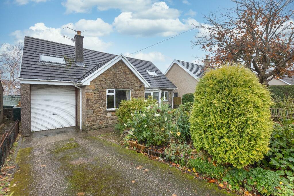
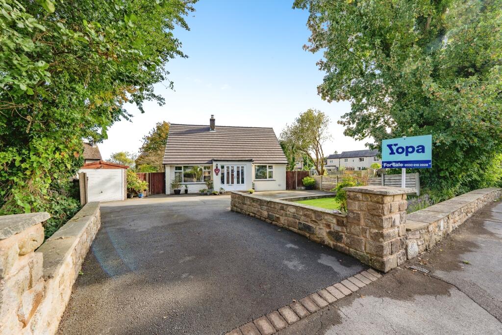
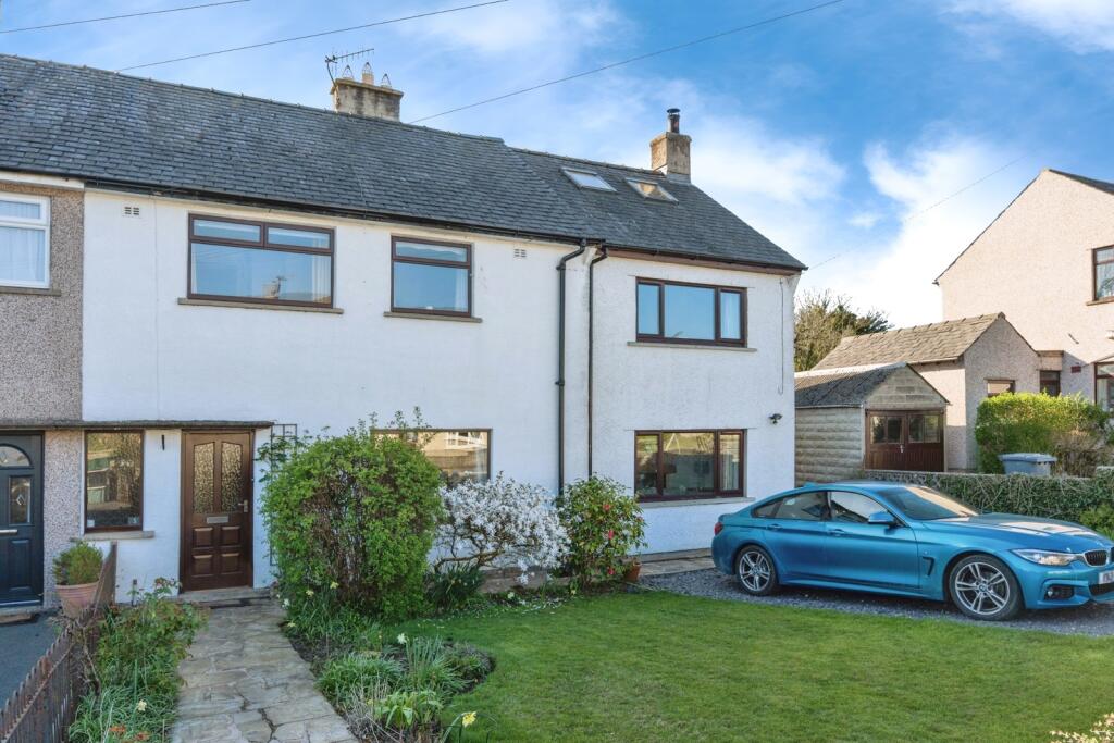
68 Quernmore Road
Caton, Lancaster, LA2 9NE

Description
Exceptional Opportunity! 2-bed detached bungalow in sought-after village with No Chain! Spacious layout, extended sunroom, and large rear garden. Double driveway & parking! This is a great opportunity for those ready to do some updating!
Key Facts
About Us
Our Story
Lancastrian Estates is an established, family run estate and letting agent who help people move across Lancashire. Set up in 2005 by David Robinson, Lancastrian Estates traded as Cumbrian Properties until the name changed in 2014. However, the Robinsons family roots go back much further than that and the business is built on over 100 years of Lancashire property experience. Today’s generation of the family are often invited out to market houses, flats and bungalows in Lancaster, Morecambe, Preston and South Ribble that were built by previous generations of the Robinson family. In fact, a third of Morecambe’s homes are likely to have been built by a Robinson!
Proud to carry on the Robinsons property legacy under Lancastrian Estates, we have exciting plans for growth going forward to help even more people move across Lancashire.
Generate a full report on your own property including an instant estimated valuation.
Title Plan
 Contains OS data © Crown copyright 2025
Title Information
Details provided by the Land Registry
- Title Number
- LAN179202
- Plot Size
- 0.35 acres (1406 sq metres)
Street View
Videos & Virtual Tours
House Prices in Lancaster
Last 12 months
-
Average Price Change
£195,891
Decreased by 100%
-
Detached Price Change
£334,712
Decreased by 100%
Average House Prices
Last 12 months for all property types.
Since - June 2020
-
Average Price Change
£141,672
Decreased by 100%
-
Detached Price Change
£246,456
Decreased by 100%
Average House Prices
Since 2020 for all property types
EPC

EPC Information
Details taken from the EPC register
- Date
- 2020-12-02
- Valid Until
- 2030-12-01
- Energy Efficiency - Current
- 56
- Energy Efficiency - Potential
- 72
- Environmental Impact - Current
- 47
- Environmental Impact - Potential
- 64
Properties For Sale in the Area
Broadacre
0.16 km away
Broadacre
0.16 km away
Broadacre View
0.22 km away
Kingfisher Court
0.25 km away
Escowbeck House
0.33 km away
Roman Crescent
0.38 km away
Properties To Let in the Area
 We couldn’t find properties to let in the area for this property.
Schools
| Name | Type | Postcode | Distance | Rating |
|---|---|---|---|---|
| Caton Primary School | Primary | LA2 9NH | 0.17 km | Good |
| Caton St Paul's Church of England Primary School | Nursery, Primary | LA2 9PJ | 1.31 km | Good |
| St Wilfrid's Cof E Primary School | Primary | LA2 6QE | 2.70 km | Good |
| Quernmore Church of England Voluntary Controlled Primary School | Primary | LA2 9EL | 4.05 km | Good |
| Central Lancaster High School | Secondary | LA1 3LS | 4.56 km | Good |
Transport
Bus Stops & Stations
Details provided by Department for Transport
| Name | Distance |
|---|---|
| Community Ps, Broadacre | 0.20 km |
| Hall Drive | 0.43 km |
| Copy Lane | 0.43 km |
| Beckside, Brookhouse Road | 0.47 km |
| Station Hotel, Brookhouse Road | 0.53 km |
Train Stations
Details provided by Department for Transport
| Name | Distance |
|---|
Nearest Motorway
Details provided by Department for Transport
| Name | Distance |
|---|---|
| M6 | 3.34 km |
Coverage
- Average Broadband Speed:
-
16mb Basic
-
41mb Superfast
-
1000mb Ultrafast
-
1000mb Overall
- Mobile Coverage:
-
EEOkay
-
O2Good
-
ThreeOkay
-
VodafoneOkay

Recently Sold Properties in the Area
| Address | Property Type | Distance | Price | Completed |
|---|---|---|---|---|
|
52 Quernmore Road Caton, Lancaster, LA2 9NE |
Detached | 0.11 km away | £450,000 | 5 months ago |
|
37 Fell View Caton, Lancaster, LA2 9RB |
Terraced | 0.19 km away | £185,000 | 5 months ago |
|
4 Artlebeck Grove Caton, Lancaster, LA2 9RH |
Semi-Detached | 0.55 km away | £170,000 | 9 months ago |
|
10 Artlebeck Road Caton, Lancaster, LA2 9RQ |
Semi-Detached | 0.55 km away | £199,000 | 8 months ago |
|
Stone Cottage, Lancaster Road Caton, Lancaster, LA2 9HX |
Detached | 0.58 km away | £450,000 | 10 months ago |
|
21 Ashcroft Close Caton, Lancaster, LA2 9RX |
Terraced | 0.61 km away | £179,000 | 11 months ago |
|
19 Hawthorn Close Brookhouse, Lancaster, LA2 9NR |
Detached | 0.63 km away | £200,000 | 10 months ago |
|
49 Hornby Road Caton, Lancaster, LA2 9QR |
Detached | 0.67 km away | £330,000 | 8 months ago |
|
44 Artlebeck Road Caton, Lancaster, LA2 9RL |
Terraced | 0.68 km away | £178,000 | 8 months ago |
|
48 Artlebeck Road Caton, Lancaster, LA2 9RL |
Terraced | 0.69 km away | £197,000 | 8 months ago |
Important Notice - This report is intended for general informational purposes only and should act only as a guide. The report is produced automatically on behalf of Lancastrian Estates - Lancastrian Estates - Lancaster by Street Insights, a product of Street Systems Ltd. Street Systems maintains and aggregates data from multiple public data sources and whilst every effort is made to keep information up to date and accurate, we make no representations or warranties of any kind about the accuracy, reliability or completeness of the information contained within this report for any purpose. Any reliance you place on the data contained within this report is strictly at your own risk. In no event will Lancastrian Estates - Lancastrian Estates - Lancaster or Street Systems Ltd be liable for any loss or damage including without limitation, indirect or consequential loss or damage, or any loss or damage whatsoever arising from loss of data or profits arising out of, or in connection with, the use of this report.
This report contains public sector information licensed under the Open Government License v3.0
Transaction data and HPI data is produced by HM Land Registry. Crown copyright and database rights 2025