Property Information Report
Orlanda Avenue
Salford, M6
Description
Spacious Three Bedroom, Semi-Detached Property Located in the Popular ‘O-Zone’, Within Walking Distance of Salford Royal Hospital and Within Catchment of Ellesmere Park High School!
As you enter the property you head into an entrance hallway, which provides access to a wet room, and a spacious lounge. Towards the rear of the property you will find a kitchen diner, with patio doors to the rear.
Upstairs, there are three well-proportioned bedrooms and a three-piece bathroom. Externally, there is a driveway for off-road parking to the front, and gardens to the front and rear.
Whilst the property is in need of modernisation, it would be great for someone who is looking for the opportunity to put their own stamp on a property – and move into a great location!
The property benefits from access to excellent transport links into Salford Quays, Media City and Manchester City Centre.
Viewing is highly recommended – get in touch to secure your viewing today!
Key Facts
About Us

About Us
Passionate about what we do. Here to serve the people of Salford and Greater Manchester and dedicated to helping you find your perfect home. Meet the multi-award winning team of property professionals at Hills.
Generate a full report on your own property including an instant estimated valuation.
Title Plan
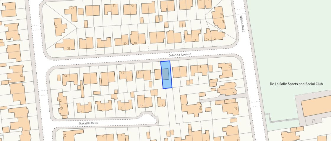 Contains OS data © Crown copyright 2025
Title Information
Details provided by the Land Registry
- Title Number
- GM77814
- Plot Size
- 0.04 acres (174 sq metres)
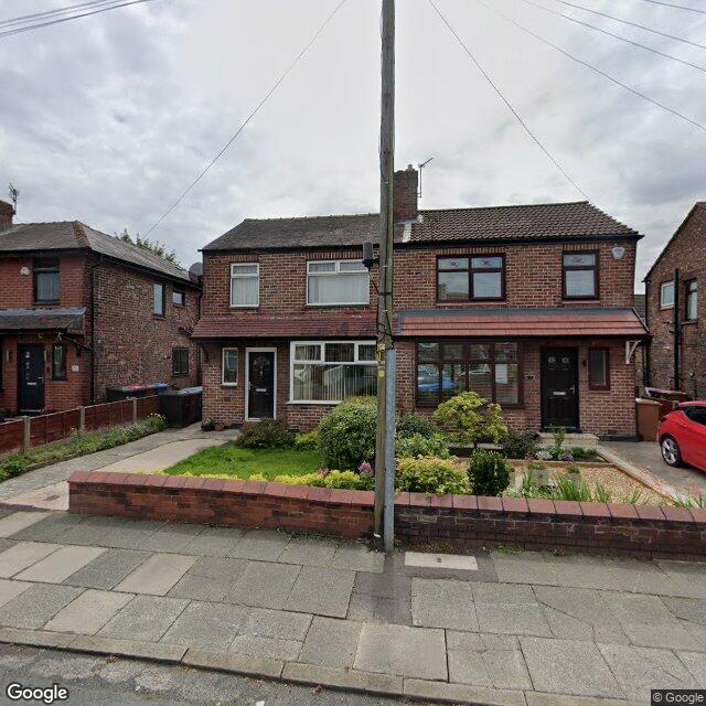
Street View

EPC
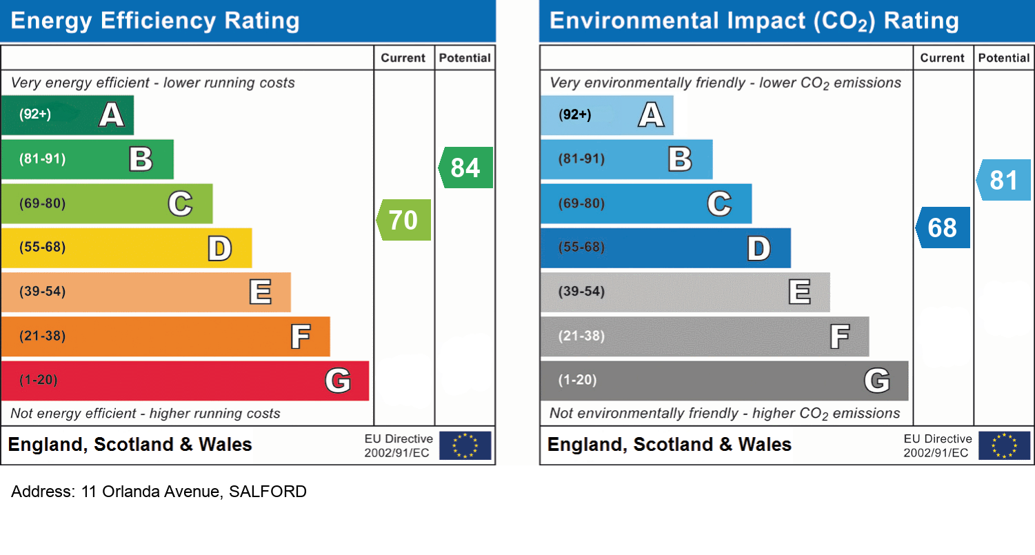
EPC Information
Details taken from the EPC register
- Date
- 2025-02-18
- Valid Until
- 2035-02-17
- Energy Efficiency - Current
- 70
- Energy Efficiency - Potential
- 84
- Environmental Impact - Current
- 68
- Environmental Impact - Potential
- 81
Hills Salfords Estate Agents
Schools
| Name | Type | Postcode | Distance | Rating |
|---|---|---|---|---|
| Light Oaks Infant School | Nursery, Primary | M6 8LU | 0.47 km | Good |
| Light Oaks Junior School | Primary | M6 8LU | 0.47 km | Good |
| Ellesmere Park High School | Secondary | M30 9BP | 0.51 km | Good |
| All Hallows RC High School | Secondary | M6 8AA | 0.69 km | Good |
| Chatsworth High School and Community College | Special | M30 9DY | 0.73 km | Outstanding |
Transport
Bus Stops & Stations
Details provided by Department for Transport
| Name | Distance |
|---|---|
| Portland Road | 0.21 km |
| St Georges Crescent, Park Road | 0.21 km |
| St George'S Crescent, Park Road | 0.24 km |
| Cholmondley Road | 0.28 km |
| Park Road | 0.28 km |
Train Stations
Details provided by Department for Transport
| Name | Distance |
|---|---|
| Eccles Rail Station | 1.03 km |
| Patricroft Rail Station | 2.36 km |
| Swinton (Manchester) Rail Station | 2.60 km |
| Moorside Rail Station | 3.16 km |
| Salford Crescent Rail Station | 3.33 km |
Nearest Motorway
Details provided by Department for Transport
| Name | Distance |
|---|---|
| M602 | 0.80 km |
Tram and Metro Stations
Details provided by Department for Transport
| Name | Distance |
|---|---|
| Ladywell (Manchester Metrolink) | 0.97 km |
| Eccles (Manchester Metrolink) | 1.28 km |
Coverage
- Average Broadband Speed:
-
13mb Basic
-
32mb Superfast
-
1000mb Ultrafast
-
1000mb Overall
- Mobile Coverage:
-
EEOkay
-
O2Good
-
ThreeOkay
-
VodafoneOkay
Important Notice - This report is intended for general informational purposes only and should act only as a guide. The report is produced automatically on behalf of Hills - Hills by Street Insights, a product of Street Systems Ltd. Street Systems maintains and aggregates data from multiple public data sources and whilst every effort is made to keep information up to date and accurate, we make no representations or warranties of any kind about the accuracy, reliability or completeness of the information contained within this report for any purpose. Any reliance you place on the data contained within this report is strictly at your own risk. In no event will Hills - Hills or Street Systems Ltd be liable for any loss or damage including without limitation, indirect or consequential loss or damage, or any loss or damage whatsoever arising from loss of data or profits arising out of, or in connection with, the use of this report.
This report contains public sector information licensed under the Open Government License v3.0
Transaction data and HPI data is produced by HM Land Registry. Crown copyright and database rights 2025