Property Information Report
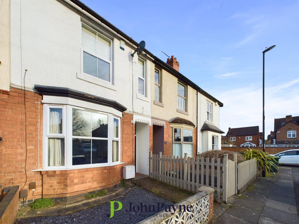
Warwick Avenue
Coventry, CV5

Description
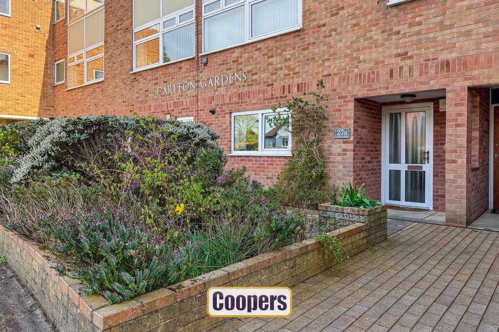
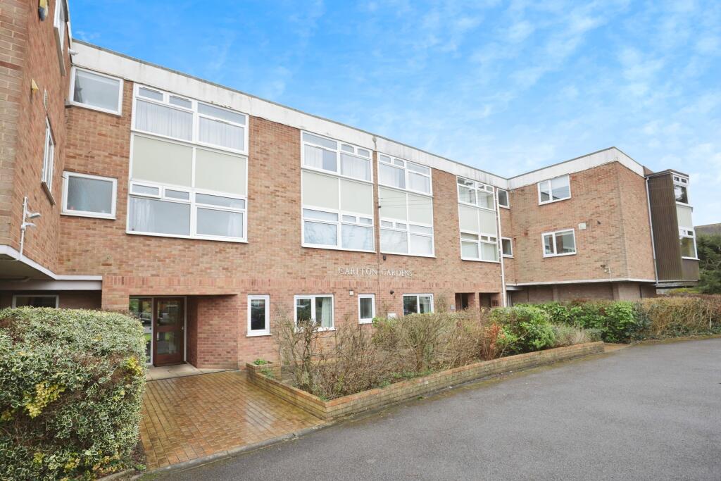
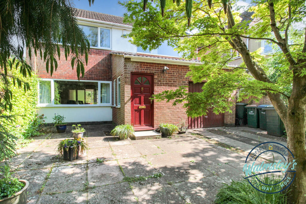
Almost certainly the best apartment in the whole of Coventry! This superb, private and self contained apartment is on the ground floor with its own front door and enjoying panoramic views of the superb Carlton Gardens.
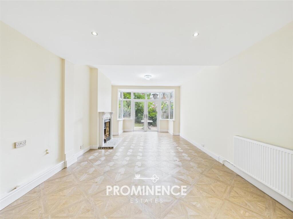
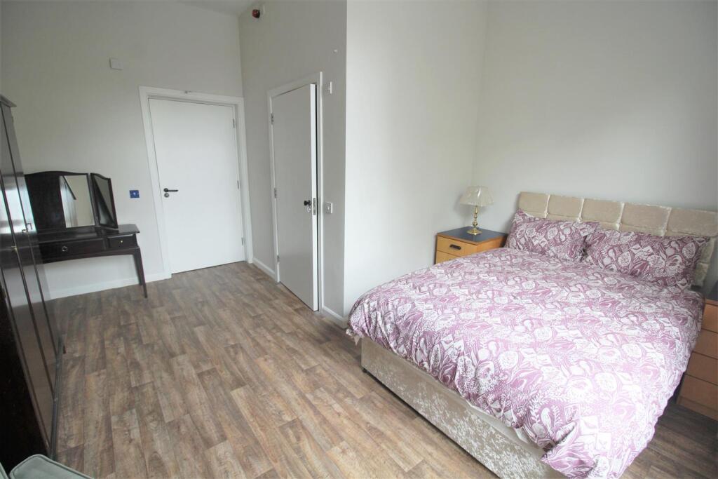
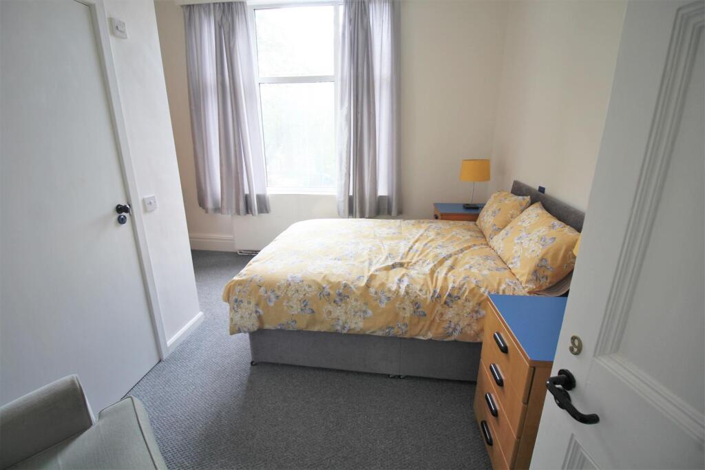
This is no ordinary apartment as the rooms are spacious and well planned and offers a unique opportunity. The well proportioned living room has fantastic views, there is a larger than usual breakfast kitchen, huge master bedroom with ensuite bathroom, second double bedroom and spacious shower room.
Carlton Gardens is approached via an in-and-out driveway with visitor parking, and the property has its own private brick garage which is within a few steps of the rear french doors to the property.
Key Facts
No lease data available
Title Plan
 We couldn’t find a title plan for this property.
Street View
House Prices in Coventry
Last 12 months
-
Average Price Change
£13,169
Increased by 6%
-
Flats/Maisonettes Price Change
£6,374
Increased by 5%
Average House Prices
Last 12 months for all property types.
Since - April 2020
-
Average Price Change
£42,873
Increased by 24%
-
Flats/Maisonettes Price Change
£22,776
Increased by 21%
Average House Prices
Since 2020 for all property types
EPC

EPC Information
Details taken from the EPC register
- Date
- 2025-04-09
- Valid Until
- 2035-04-08
- Energy Efficiency - Current
- 71
- Energy Efficiency - Potential
- 76
- Environmental Impact - Current
- 70
- Environmental Impact - Potential
- 76
Properties For Sale in the Area
Carlton Gardens
1 metres away
Carlton Gardens
82 metres away
Warwick Avenue
99 metres away
Warwick Avenue
99 metres away
5a Warwick Avenue
0.12 km away
Styvechale Avenue
0.16 km away
Properties To Let in the Area
Warwick Avenue
49 metres away
Carlton Gardens
82 metres away
Stanley Road
0.21 km away
Earlsdon Avenue South
0.24 km away
Ensuite 8
0.27 km away
Earlsdon Avenue South
0.27 km away
Schools
| Name | Type | Postcode | Distance | Rating |
|---|---|---|---|---|
| Earlsdon Primary School | Primary | CV5 6FZ | 0.64 km | Good |
| King Henry VIII School | Independent, Nursery, Primary, Post 16 | CV3 6AQ | 0.89 km | Not rated |
| Stivichall Primary School | Primary | CV3 6PY | 0.95 km | Good |
| Hearsall Community Academy | Nursery, Primary | CV5 6LR | 1.02 km | Good |
| All Souls' Catholic Primary School | Nursery, Primary | CV5 8ED | 1.35 km | Good |
Transport
Train Stations
Details provided by Department for Transport
| Name | Distance |
|---|---|
| Coventry Rail Station | 1.17 km |
| Canley Rail Station | 1.38 km |
| Tile Hill Rail Station | 4.65 km |
Nearest Motorway
Details provided by Department for Transport
| Name | Distance |
|---|---|
| M6 | 7.87 km |
Airports
Details provided by Department for Transport
| Name | Distance |
|---|---|
| Coventry Airport | 4.75 km |
| Birmingham International Airport | 15.18 km |
| East Midlands Airport | 49.76 km |
| London Oxford Airport | 64.41 km |
| Gloucestershire Airport | 70.82 km |
Coverage
- Average Broadband Speed:
-
15mb Basic
-
69mb Superfast
-
1800mb Ultrafast
-
1800mb Overall
- Mobile Coverage:
-
EEOkay
-
O2Good
-
ThreeOkay
-
VodafoneOkay
Recently Sold Properties in the Area
| Address | Property Type | Distance | Price | Completed |
|---|---|---|---|---|
|
30 Warwick Avenue Coventry, CV5 6DG |
Detached | 47 metres away | £760,000 | 10 months ago |
|
8 Styvechale Avenue Coventry, CV5 6DX |
Semi-Detached | 0.18 km away | £575,000 | 7 months ago |
|
39d, Belvedere Road Coventry, CV5 6PG |
Flats/Maisonettes | 0.21 km away | £71,000 | 11 months ago |
|
30 Avondale Road Coventry, CV5 6DZ |
Semi-Detached | 0.24 km away | £415,000 | 7 months ago |
|
46 Earlsdon Avenue South Coventry, CV5 6DT |
Semi-Detached | 0.24 km away | £350,000 | 5 months ago |
|
10 Osborne Road Coventry, CV5 6DY |
Terraced | 0.24 km away | £248,000 | 6 months ago |
|
3 Avondale Road Coventry, CV5 6DZ |
Terraced | 0.26 km away | £445,000 | 10 months ago |
|
11 Avondale Road Coventry, CV5 6DZ |
Terraced | 0.26 km away | £445,000 | 7 months ago |
|
15 Osborne Road Coventry, CV5 6DY |
Terraced | 0.26 km away | £187,500 | 8 months ago |
|
Flat 3, Aylesdene Court, Osborne Road Coventry, CV5 6SB |
Flats/Maisonettes | 0.26 km away | £125,000 | 11 months ago |
Important Notice - This report is intended for general informational purposes only and should act only as a guide. The report is produced automatically on behalf of Coopers Estate Agents - Coventry by Street Insights, a product of Street Systems Ltd. Street Systems maintains and aggregates data from multiple public data sources and whilst every effort is made to keep information up to date and accurate, we make no representations or warranties of any kind about the accuracy, reliability or completeness of the information contained within this report for any purpose. Any reliance you place on the data contained within this report is strictly at your own risk. In no event will Coopers Estate Agents - Coventry or Street Systems Ltd be liable for any loss or damage including without limitation, indirect or consequential loss or damage, or any loss or damage whatsoever arising from loss of data or profits arising out of, or in connection with, the use of this report.
This report contains public sector information licensed under the Open Government License v3.0
Transaction data and HPI data is produced by HM Land Registry. Crown copyright and database rights 2025