Property Information Report
Chaseley Road
Salford, M6
Description
**FANTASTIC OPPORTUNITY** This spacious three bedroom semi-detached property is situated on a popular, tree-lined road! Within walking distance of Buile Hill Park and close to excellent transport links!
As you enter the property you go into a welcoming entrance hallway, which leads to the bay-fronted lounge, the spacious dining room, and to the kitchen/utility area. From here, you will find the downstairs W/C and another room which continues the kitchen space.
Upstairs there are three well-proportioned bedrooms, and a bathroom with a separate W/C.
Externally, there is a driveway to the front for off-road parking, along with a mature garden. To the side, there is a carport which is currently used for storage, and to the rear there is a mature garden with a patio area.
Properties in this location are popular due to their close access to excellent transport links into Salford Quay, Media City and Manchester City Centre. It is also close to Salford Royal Hospital, Buile Hill Park and local schooling.
Viewing is highly recommended - get in touch to secure your viewing today!
Key Facts
About Us

About Us
Passionate about what we do. Here to serve the people of Salford and Greater Manchester and dedicated to helping you find your perfect home. Meet the multi-award winning team of property professionals at Hills.
Generate a full report on your own property including an instant estimated valuation.
Title Plan
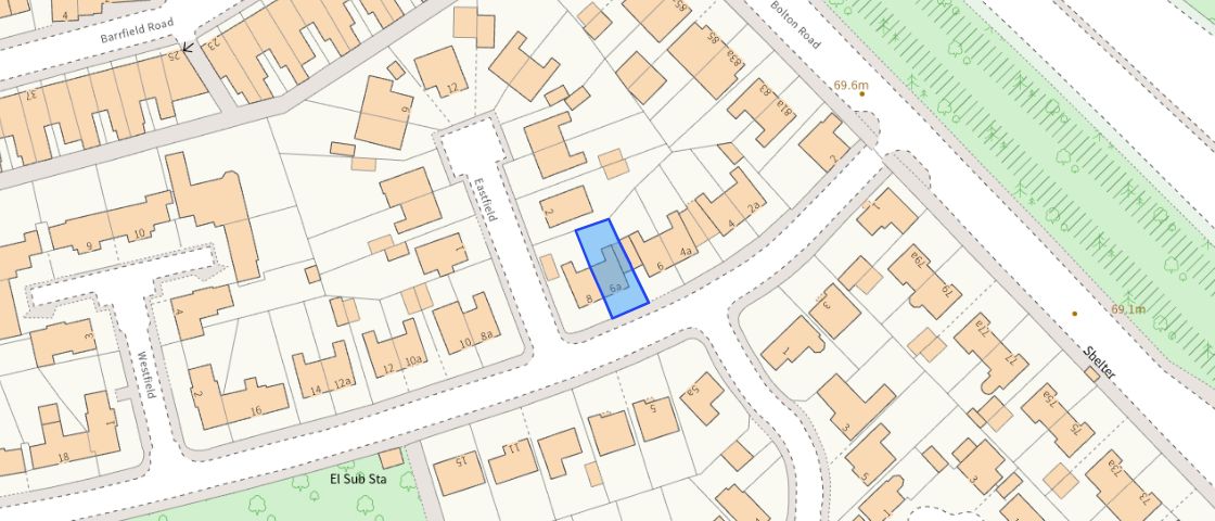 Contains OS data © Crown copyright 2025
Title Information
Details provided by the Land Registry
- Title Number
- LA258609
- Plot Size
- 0.04 acres (181 sq metres)
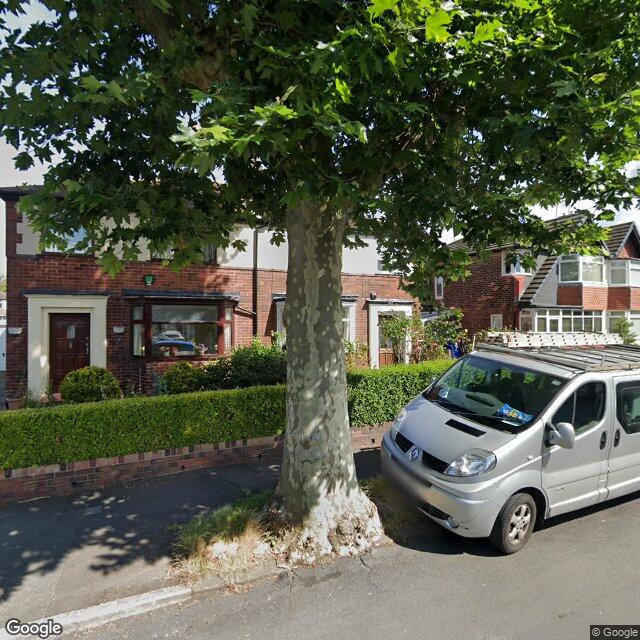
Street View
EPC
 No EPC data available for this property.
Hills Salfords Estate Agents
Schools
| Name | Type | Postcode | Distance | Rating |
|---|---|---|---|---|
| Buile Hill Academy | Secondary | M6 8RD | 0.29 km | Not rated |
| Buile Hill Academy | Secondary | M6 8RD | 0.29 km | Not rated |
| Summerville Primary School | Nursery, Primary | M6 7HB | 0.62 km | Good |
| Holy Family VA RC Primary School | Nursery, Primary | M6 5WX | 0.81 km | Outstanding |
| St Luke's CofE Primary School | Nursery, Primary | M5 5JH | 0.96 km | Not rated |
Transport
Bus Stops & Stations
Details provided by Department for Transport
| Name | Distance |
|---|---|
| Barrfield Road | 0.13 km |
| Brentwood, Eccles Old Road | 0.32 km |
| Langworthy Road | 0.35 km |
| Chaseley Road | 0.37 km |
| Sorrel Bank, Bolton Road | 0.39 km |
Train Stations
Details provided by Department for Transport
| Name | Distance |
|---|---|
| Salford Crescent Rail Station | 1.77 km |
| Eccles Rail Station | 2.60 km |
| Salford Central Rail Station | 3.17 km |
| Clifton (Manchester) Rail Station | 3.26 km |
Nearest Motorway
Details provided by Department for Transport
| Name | Distance |
|---|---|
| M602 | 1.91 km |
Coverage
- Average Broadband Speed:
-
12mb Basic
-
34mb Superfast
-
2000mb Ultrafast
-
2000mb Overall
- Mobile Coverage:
-
EEOkay
-
O2Good
-
ThreePoor
-
VodafoneOkay
Important Notice - This report is intended for general informational purposes only and should act only as a guide. The report is produced automatically on behalf of Hills - Hills by Street Insights, a product of Street Systems Ltd. Street Systems maintains and aggregates data from multiple public data sources and whilst every effort is made to keep information up to date and accurate, we make no representations or warranties of any kind about the accuracy, reliability or completeness of the information contained within this report for any purpose. Any reliance you place on the data contained within this report is strictly at your own risk. In no event will Hills - Hills or Street Systems Ltd be liable for any loss or damage including without limitation, indirect or consequential loss or damage, or any loss or damage whatsoever arising from loss of data or profits arising out of, or in connection with, the use of this report.
This report contains public sector information licensed under the Open Government License v3.0
Transaction data and HPI data is produced by HM Land Registry. Crown copyright and database rights 2025