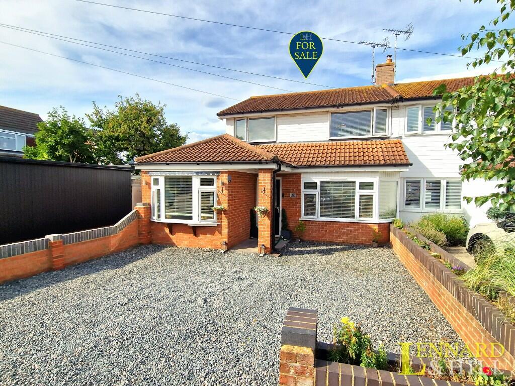
Property Information Report
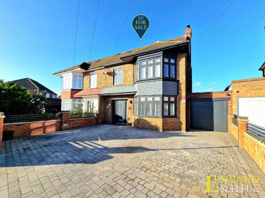
93 Wood View
Grays, RM16 2GP
Estimated Value - £500,000
Estimated Rental Value - £1,875 PCM
Last Sold - Sep, 2024


Key Facts
Title Plan
 Contains OS data © Crown copyright 2025
Title Information
Details provided by the Land Registry
- Title Number
- EX815166
- Plot Size
- 0.12 acres (467 sq metres)
Street View
EPC

EPC Information
Details taken from the EPC register
- Date
- 2018-07-18
- Valid Until
- 2028-07-17
- Energy Efficiency - Current
- 49
- Energy Efficiency - Potential
- 79
- Environmental Impact - Current
- 41
- Environmental Impact - Potential
- 74
Description
Situated on an elevated plot in this prestigious location is this 3 bedroom semi detached house with a long independent driveway leading to a garage. The property is spacious with a large hall, 2 reception rooms that both have bay windows complemented by 3 good sized bedrooms. The garden is 91' in length. No chain.
GROUND FLOOR
PORCH
Entrance door and adjacent windows. Quarry tiled floor. Further door and adjacent windows.
LARGE ENTRANCE HALL 3.76m (12'4) x 1.78m (5'10) min plus an area with the stairs.
Stairs to first floor. Radiator. Coving to ceiling. Doors to rooms. Laminate floor.
LOUNGE 3.94m (12'11") into bay x 3.88m (12'9")
Deep double glazed bay window to front. Two windows to side. Laminate floor. Skirting radiators.
TOILET
Opaque double glazed window to side. Low level WC & wall fixed wash basin. Laminate floor.
DINING ROOM 3.32m (10'11") x 3.18m (10'5") < 4.22m (13'10) into bay
Double glazed bay window to rear overlooking the garden. A lovely parquet floor. Radiator.
FITTED KITCHEN 3.18m (10'5") x 2.82m (9'3")
Double glazed window to rear, door to side drive. Fitted cupboards. Wall boiler.
SPACIOUS FIRST FLOOR LANDING
Double glazed window to side. Storage cupboards. Doors to rooms.
BEDROOM 1 3.94m (12'11") < 4.88m (16') into bay x 3.88m (12'9")
Deep double glazed bay window to front. Radiator. Fitted wardrobes.
BEDROOM 2 3.32m (10'11") x 3.18m (10'5") < 4.14m (13'7) into bay
Deep double glazed bay window to rear overlooking the garden. Built-in cupboard. Radiator.
BEDROOM 3 3.61m (11'10") x 2.27m (7'5")
Double glazed window to front. Part sloping ceiling. Radiator.
BATHROOM
Opaque double glazed window to rear. Ceramic tiled walls. Suite comprising panelled bath, pedestal wash basin, low level WC & shower enclosure. Radiator.
EXTERIOR
Situated on an elevated plot in a prestigious turning. A front wall and lawn with an adjacent independent drive leading to the GARAGE 23'7 x 9'3 max. There is a hardstanding area in front of the garage and/or patio area. There is a 91' rear garden mostly laid to lawn.
Schools
| Name | Type | Postcode | Distance | Rating |
|---|---|---|---|---|
| Woodside Academy | Nursery, Primary | RM16 2GJ | 0.33 km | Good |
| Treetops Free School | Special | RM16 2WU | 0.76 km | Good |
| Treetops School | Special | RM16 2WU | 0.76 km | Outstanding |
| Little Thurrock Primary School | Nursery, Primary | RM17 5SW | 0.89 km | Good |
| Chadwell St Mary Primary School | Primary | RM16 4DH | 1.12 km | Good |
Coverage
- Average Broadband Speed:
-
5mb Basic
-
33mb Superfast
-
1000mb Ultrafast
-
1000mb Overall
- Mobile Coverage:
-
EEOkay
-
O2Good
-
ThreeOkay
-
VodafoneOkay
Transport
Bus Stops & Stations
Details provided by Department for Transport
| Name | Distance |
|---|---|
| Heathland Way | 0.14 km |
| Palmers College, Chadwell Road | 0.15 km |
| Wood View, Wood View | 0.21 km |
| Grangewood Avenue | 0.36 km |
| Chadwell Road Cemetery, Chadwell Road | 0.39 km |
Train Stations
Details provided by Department for Transport
| Name | Distance |
|---|---|
| Grays Rail Station | 2.37 km |
| Tilbury Town Rail Station | 2.49 km |
| East Tilbury Rail Station | 4.23 km |
| Chafford Hundred Rail Station | 4.50 km |
| Northfleet Rail Station | 4.79 km |
Nearest Motorway
Details provided by Department for Transport
| Name | Distance |
|---|---|
| M25 | 5.91 km |
Properties For Sale in the Area
Masefield Road
0.77 km away
Badgers Mount
1.08 km away
Rushley Close
1.54 km away
Long Lane
1.80 km away
The Green
3.09 km away
House Prices in Thurrock
Last 12 months
-
Average Price Change
£14,912
Increased by 5%
-
Semi-Detached Price Change
£19,248
Increased by 5%
Average House Prices
Last 12 months for all property types.
Since Last Sale - 5th September 2024
-
Average Price Change
£55,159
Increased by 20%
-
Semi-Detached Price Change
£73,900
Increased by 22%
Average House Prices
Since 2020 for all property types
Recently Sold Properties in the Area
| Address | Property Type | Distance | Price | Completed |
|---|---|---|---|---|
|
93 Wood View Grays, RM16 2GP |
Semi-Detached | away | £490,000 | 8 months ago |
|
5 Culverin Avenue Grays, RM16 2BF |
Semi-Detached | 57 metres away | £410,000 | 8 months ago |
|
23 Heathland Way Grays, RM16 2DF |
Terraced | 81 metres away | £357,500 | 5 months ago |
|
16 Heathland Way Grays, RM16 2DQ |
Semi-Detached | 88 metres away | £400,000 | 8 months ago |
|
12 Culverin Avenue Grays, RM16 2BF |
Detached | 0.11 km away | £400,000 | 2 months ago |
|
24 Colburn Way Grays, RM16 2EG |
Semi-Detached | 0.16 km away | £410,000 | 7 months ago |
|
30 Barrow Hall House, Woodside Close Grays, RM16 2EW |
Flats/Maisonettes | 0.22 km away | £188,500 | 6 months ago |
|
38 Barrow Hall House, Woodside Close Grays, RM16 2EW |
Flats/Maisonettes | 0.22 km away | £215,000 | 9 months ago |
|
37 Woodside Close Grays, RM16 2DN |
Semi-Detached | 0.27 km away | £410,000 | 7 months ago |
|
41 Woodside Close Grays, RM16 2DN |
Semi-Detached | 0.27 km away | £425,000 | 7 months ago |
About Us

Lennard & Hill Residential
With almost 40 years in the industry and 20 years of Lennard & Hill, there isn't much we don't know about moving home. As a family owned and run estate agency, ours is a personal service and we simply aim to use this experience to make your move as stress-free as possible, from valuation to moving day.
Find out more at our Website
Generate a full report on your own property including an instant estimated valuation.
Important Notice - This report is intended for general informational purposes only and should act only as a guide. The report is produced automatically on behalf of Lennard & Hill Residential - Joe Lennard by Street Insights, a product of Street Systems Ltd. Street Systems maintains and aggregates data from multiple public data sources and whilst every effort is made to keep information up to date and accurate, we make no representations or warranties of any kind about the accuracy, reliability or completeness of the information contained within this report for any purpose. Any reliance you place on the data contained within this report is strictly at your own risk. In no event will Lennard & Hill Residential - Joe Lennard or Street Systems Ltd be liable for any loss or damage including without limitation, indirect or consequential loss or damage, or any loss or damage whatsoever arising from loss of data or profits arising out of, or in connection with, the use of this report.
This report contains public sector information licensed under the Open Government License v3.0
Transaction data and HPI data is produced by HM Land Registry. Crown copyright and database rights 2025