Buyer Information Report
30 Augustine Drive
Finberry, Ashford, TN25 7GH
Estimated Value - £460,000
Estimated Rental Value - £1,500 PCM
Last Sold - Oct, 2024

Key Facts
Title Plan
 Contains OS data © Crown copyright 2025
Title Information
Details provided by the Land Registry
- Title Number
- TT90049
- Plot Size
- 0.07 acres (270 sq metres)
Street View
House Prices in Ashford
Last 12 months
-
Average Price Change
£8,874
Increased by 3%
-
Detached Price Change
£23,450
Increased by 4%
Average House Prices
Last 12 months for all property types.
Since Last Sale - 2nd October 2024
-
Average Price Change
£56,619
Increased by 20%
-
Detached Price Change
£97,229
Increased by 21%
Average House Prices
Since 2020 for all property types
EPC
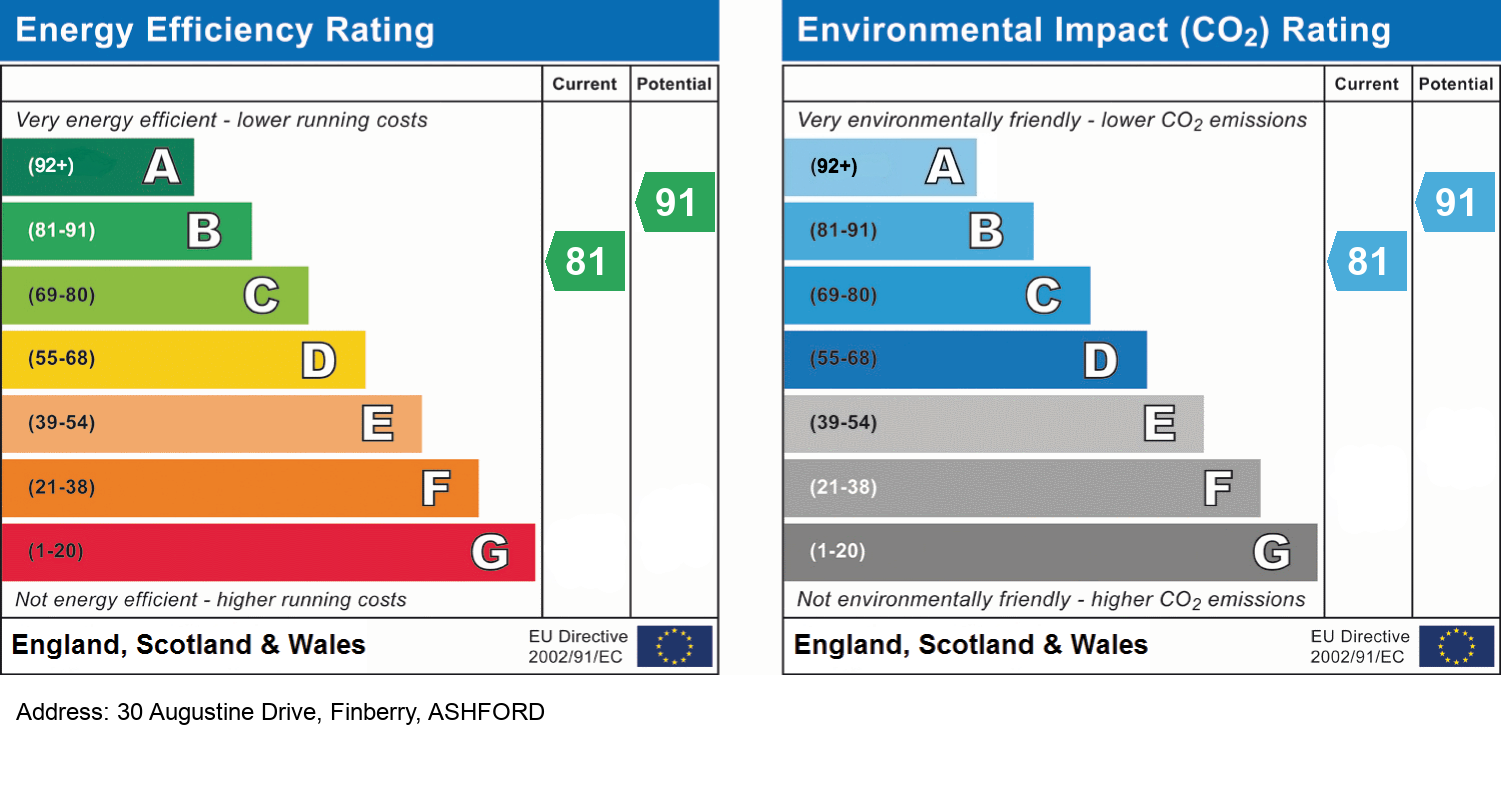
EPC Information
Details taken from the EPC register
- Date
- 2017-03-01
- Valid Until
- 2027-02-28
- Energy Efficiency - Current
- 81
- Energy Efficiency - Potential
- 91
- Environmental Impact - Current
- 81
- Environmental Impact - Potential
- 91
Schools
| Name | Type | Postcode | Distance | Rating |
|---|---|---|---|---|
| Finberry Primary School | Special, Nursery | TN25 7GS | 0.52 km | Good |
| Furley Park Primary Academy | Primary | TN23 3PA | 1.51 km | Not rated |
| East Stour Primary School | Nursery, Primary | TN24 0DW | 1.71 km | Not rated |
| Mersham Primary School | Primary | TN25 6NU | 2.17 km | Good |
| Kingsnorth Church of England Primary School | Primary | TN23 3EF | 2.29 km | Good |
Transport
Bus Stops & Stations
Details provided by Department for Transport
| Name | Distance |
|---|---|
| Song Thrush Drive | 0.39 km |
| Avocet Way Roundabout, Avocet Way | 0.45 km |
| Farm, Cheeseman's Green Lane | 0.54 km |
| Finberry Entrance, Avocet Way | 0.96 km |
| Finn Farm Road | 1.06 km |
Train Stations
Details provided by Department for Transport
| Name | Distance |
|---|---|
| Ashford International Rail Station | 3.21 km |
Nearest Motorway
Details provided by Department for Transport
| Name | Distance |
|---|---|
| M20 | 2.50 km |
Coverage
- Average Broadband Speed:
-
5mb Basic
-
10000mb Ultrafast
-
10000mb Overall
- Mobile Coverage:
-
EEOkay
-
O2Okay
-
ThreeOkay
-
VodafoneOkay
Recently Sold Properties in the Area
| Address | Property Type | Distance | Price | Completed |
|---|---|---|---|---|
|
30 Augustine Drive Finberry, Ashford, TN25 7GH |
Detached | away | £410,000 | 10 months ago |
|
25 Augustine Drive Finberry, Ashford, TN25 7GH |
Terraced | 85 metres away | £296,000 | 9 months ago |
|
48 Nuthatch Drive Finberry, Ashford, TN25 7AA |
Semi-Detached | 0.12 km away | £295,000 | 8 months ago |
|
48 Augustine Drive Finberry, Ashford, TN25 7GH |
Detached | 0.12 km away | £412,500 | 10 months ago |
|
29 Augustine Drive Finberry, Ashford, TN25 7GH |
Detached | 0.12 km away | £390,000 | 5 months ago |
|
16 Augustine Drive Finberry, Ashford, TN25 7GH |
Detached | 0.14 km away | £590,000 | 6 months ago |
|
52 Nuthatch Drive Finberry, Ashford, TN25 7AA |
Detached | 0.14 km away | £340,000 | 8 months ago |
|
67 Wagtail Walk Finberry, Ashford, TN25 7GE |
Terraced | 0.16 km away | £302,500 | 10 months ago |
|
31 Swift Avenue Finberry, Ashford, TN25 7GD |
Flats/Maisonettes | 0.17 km away | £220,000 | 6 months ago |
|
19 Pipin Crescent Finberry, Ashford, TN25 7GL |
Semi-Detached | 0.18 km away | £305,000 | 4 months ago |
Important Notice - This report is intended for general informational purposes only and should act only as a guide. The report is produced automatically on behalf of Andrew & Co Estate Agents Ltd - Ashford by Street Insights, a product of Street Systems Ltd. Street Systems maintains and aggregates data from multiple public data sources and whilst every effort is made to keep information up to date and accurate, we make no representations or warranties of any kind about the accuracy, reliability or completeness of the information contained within this report for any purpose. Any reliance you place on the data contained within this report is strictly at your own risk. In no event will Andrew & Co Estate Agents Ltd - Ashford or Street Systems Ltd be liable for any loss or damage including without limitation, indirect or consequential loss or damage, or any loss or damage whatsoever arising from loss of data or profits arising out of, or in connection with, the use of this report.
This report contains public sector information licensed under the Open Government License v3.0
Transaction data and HPI data is produced by HM Land Registry. Crown copyright and database rights 2025