Buyer Information Report
356 Sandyhurst Lane
Ashford, TN25 4PE
Estimated Value - £805,000
Estimated Rental Value - £2,450 PCM
Last Sold - Aug, 2022
Key Facts
Title Plan
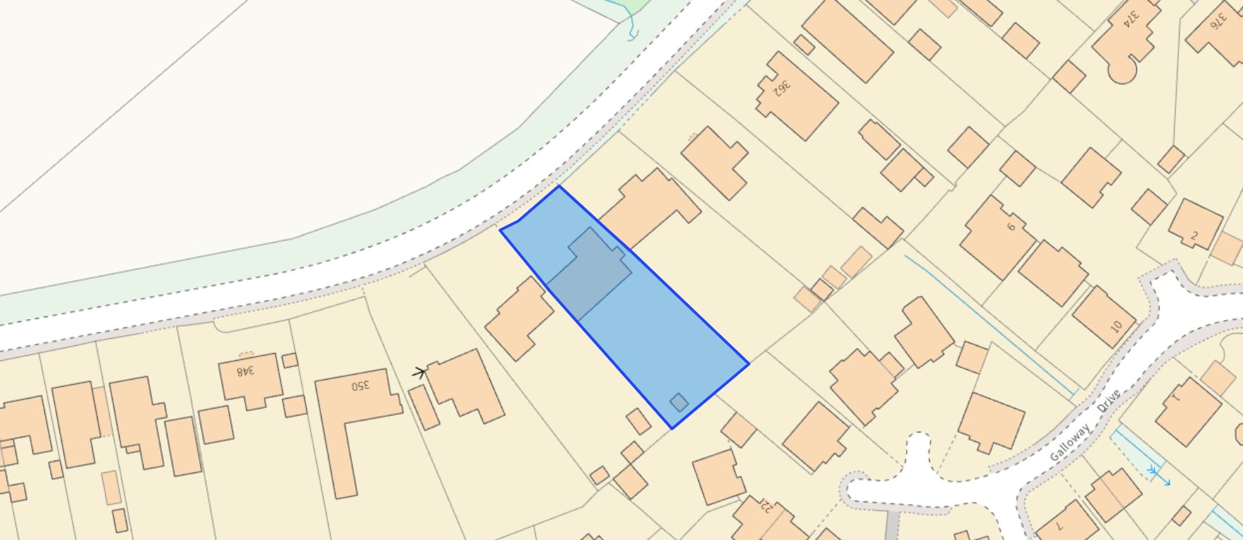 Contains OS data © Crown copyright 2025
Title Information
Details provided by the Land Registry
- Title Number
- K316347
- Plot Size
- 0.27 acres (1111 sq metres)
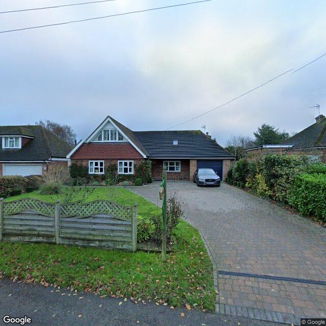
Street View
House Prices in Ashford
Last 12 months
-
Average Price Change
£14,986
Increased by 4%
-
Detached Price Change
£29,734
Increased by 5%
Average House Prices
Last 12 months for all property types.
Since Last Sale - 4th August 2022
-
Average Price Change
£15,282
Increased by 5%
-
Detached Price Change
£29,303
Increased by 5%
Average House Prices
Since last sale in 2022 for all property types
EPC
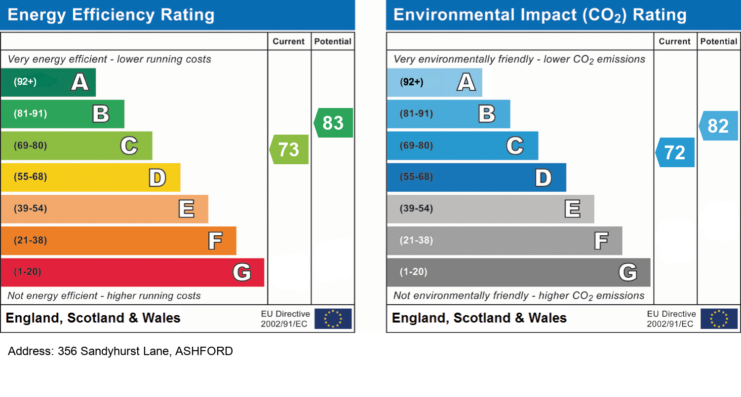
EPC Information
Details taken from the EPC register
- Date
- 2017-01-21
- Valid Until
- 2027-01-20
- Energy Efficiency - Current
- 73
- Energy Efficiency - Potential
- 83
- Environmental Impact - Current
- 72
- Environmental Impact - Potential
- 82
Schools
| Name | Type | Postcode | Distance | Rating |
|---|---|---|---|---|
| Goat Lees Primary School | Primary | TN24 9RR | 0.40 km | Good |
| Towers School and Sixth Form Centre | Secondary, Post 16 | TN24 9AL | 0.67 km | Good |
| Kennington Church of England Academy | Primary | TN24 9AG | 0.96 km | Good |
| Downs View Infant School | Primary | TN25 4PJ | 1.12 km | Good |
| Phoenix Community Primary School | Primary | TN24 9LS | 1.21 km | Good |
Transport
Bus Stops & Stations
Details provided by Department for Transport
| Name | Distance |
|---|---|
| Guernsey Way | 0.25 km |
| Jersey Close | 0.29 km |
| Hurst Road | 0.41 km |
| Eureka Place | 0.43 km |
| Eastwell Towers, Faversham Road | 0.44 km |
Train Stations
Details provided by Department for Transport
| Name | Distance |
|---|---|
| Ashford International Rail Station | 3.50 km |
| Wye Rail Station | 3.96 km |
Nearest Motorway
Details provided by Department for Transport
| Name | Distance |
|---|---|
| M20 | 1.58 km |
Coverage
- Average Broadband Speed:
-
2mb Basic
-
30mb Superfast
-
1800mb Ultrafast
-
1800mb Overall
- Mobile Coverage:
-
EEOkay
-
O2Okay
-
ThreePoor
-
VodafoneOkay
Recently Sold Properties in the Area
| Address | Property Type | Distance | Price | Completed |
|---|---|---|---|---|
|
15 Galloway Drive Kennington, Ashford, TN25 4QQ |
Flats/Maisonettes | 0.15 km away | £230,000 | 9 months ago |
|
29 Muscovy Road Kennington, Ashford, TN25 4QN |
Detached | 0.15 km away | £440,000 | 11 months ago |
|
14 Dexter Close Kennington, Ashford, TN25 4QG |
Detached | 0.20 km away | £625,000 | 2 months ago |
|
45 Galloway Drive Kennington, Ashford, TN25 4QQ |
Flats/Maisonettes | 0.20 km away | £183,000 | 9 months ago |
|
28 Dexter Close Kennington, Ashford, TN25 4QG |
Detached | 0.23 km away | £580,000 | 7 months ago |
|
19 Angus Drive Kennington, Ashford, TN24 9HW |
Flats/Maisonettes | 0.27 km away | £170,000 | 2 months ago |
|
28 Friesian Way Kennington, Ashford, TN24 9LE |
Detached | 0.28 km away | £410,000 | 4 months ago |
|
44 Guernsey Way Kennington, Ashford, TN24 9LW |
Terraced | 0.31 km away | £350,000 | 8 months ago |
|
12 Hereford Close Kennington, Ashford, TN24 9LG |
Terraced | 0.31 km away | £280,000 | 4 months ago |
|
45 Guernsey Way Kennington, Ashford, TN24 9LW |
Terraced | 0.33 km away | £362,500 | 3 months ago |
Important Notice - This report is intended for general informational purposes only and should act only as a guide. The report is produced automatically on behalf of Andrew & Co Estate Agents Ltd - Ashford by Street Insights, a product of Street Systems Ltd. Street Systems maintains and aggregates data from multiple public data sources and whilst every effort is made to keep information up to date and accurate, we make no representations or warranties of any kind about the accuracy, reliability or completeness of the information contained within this report for any purpose. Any reliance you place on the data contained within this report is strictly at your own risk. In no event will Andrew & Co Estate Agents Ltd - Ashford or Street Systems Ltd be liable for any loss or damage including without limitation, indirect or consequential loss or damage, or any loss or damage whatsoever arising from loss of data or profits arising out of, or in connection with, the use of this report.
This report contains public sector information licensed under the Open Government License v3.0
Transaction data and HPI data is produced by HM Land Registry. Crown copyright and database rights 2025