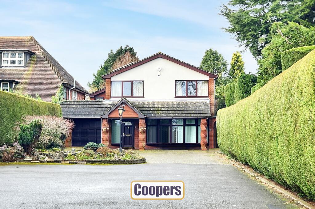
Property Information Report
St. Martins Road
Coventry, CV3

Description
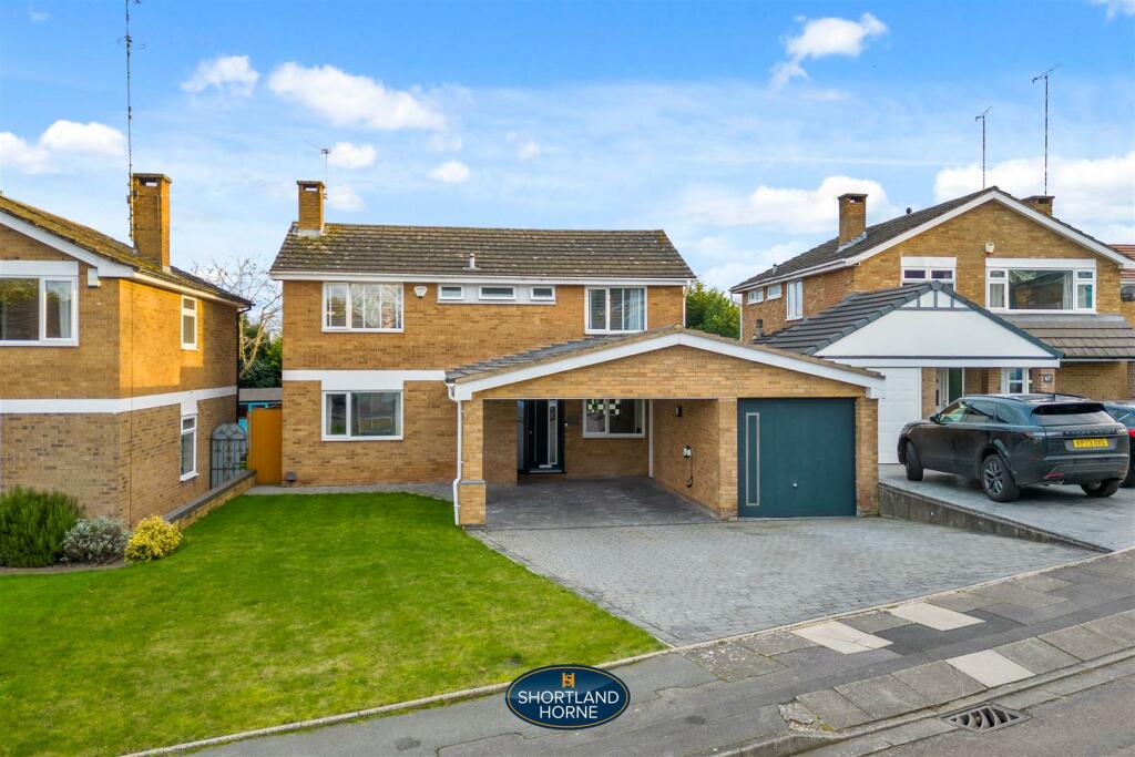
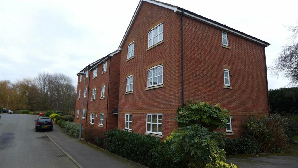
This incredibly spacious detached family home is on Coventry’s southern boundary and well set back from the road with large gardens. Internal inspection is a must as there are two extremely large receptions rooms, luxury fitted dining kitchen, ground floor utility room and cloakroom. Upstairs there are four large bedrooms, two with luxury ensuites, together with a luxury family bathroom. The landscaped gardens are most attractive and there is plenty of parking for 7/8 cars and garage and landscaped lovely rear garden.
Key Facts
Title Plan
 Contains OS data © Crown copyright 2024
Title Information
Details provided by the Land Registry
- Title Number
- WM56765
- Plot Size
- 0.20 acres (814 sq metres)
Street View
House Prices in Coventry
Last 12 months
-
Average Price Change
£7,010
Decreased by 3%
-
Detached Price Change
£6,861
Decreased by 2%
Average House Prices
Last 12 months for all property types.
Since - February 2019
-
Average Price Change
£32,921
Increased by 18%
-
Detached Price Change
£64,527
Increased by 18%
Average House Prices
Since 2019 for all property types
EPC

EPC Information
Details taken from the EPC register
- Date
- 2014-04-30
- Valid Until
- 2024-04-30
- Energy Efficiency - Current
- 74
- Energy Efficiency - Potential
- 81
- Environmental Impact - Current
- 70
- Environmental Impact - Potential
- 78
Properties For Sale in the Area
St. Martins Road
1 metres away
Finham
86 metres away
St. Martins Road
0.12 km away
Green Lane South
0.17 km away
Cotswold Drive
0.17 km away
Green Lane
0.18 km away
Properties To Let in the Area
St. Martins Road
1 metres away
Brentwood Avenue
0.40 km away
Fletcher Walk
0.70 km away
Anchorway Road
1.00 km away
Schools
| Name | Type | Postcode | Distance | Rating |
|---|---|---|---|---|
| Finham Primary School | Nursery, Primary | CV3 6EJ | 0.41 km | Good |
| Finham Park School | Secondary, Post 16 | CV3 6EA | 1.15 km | Outstanding |
| Grange Farm Primary School | Primary | CV3 6NF | 1.25 km | Good |
| St Thomas More Catholic Primary School | Nursery, Primary | CV3 5DE | 1.44 km | Not rated |
| Bishop Ullathorne Catholic School | Secondary, Post 16 | CV3 6BH | 1.71 km | Not rated |
Transport
Train Stations
Details provided by Department for Transport
| Name | Distance |
|---|---|
| Coventry Rail Station | 3.16 km |
| Canley Rail Station | 3.72 km |
Nearest Motorway
Details provided by Department for Transport
| Name | Distance |
|---|---|
| M6 | 9.40 km |
Airports
Details provided by Department for Transport
| Name | Distance |
|---|---|
| Coventry Airport | 2.76 km |
| Birmingham International Airport | 17.20 km |
| East Midlands Airport | 52.01 km |
| London Oxford Airport | 61.71 km |
| Gloucestershire Airport | 69.43 km |
Coverage
- Average Broadband Speed:
-
12mb Basic
-
1000mb Ultrafast
-
1000mb Overall
- Mobile Coverage:
-
EEGood
-
O2Good
-
ThreeGood
-
VodafoneGood
Recently Sold Properties in the Area
| Address | Property Type | Distance | Price | Completed |
|---|---|---|---|---|
|
18 Brentwood Gardens Brentwood Avenue Coventry, CV3 6AS |
Flats/Maisonettes | 0.36 km away | £95,000 | 6 months ago |
|
175 Anchorway Road Coventry, CV3 6JH |
Semi-Detached | 0.46 km away | £425,000 | 11 months ago |
|
16 Wychwood Avenue Coventry, CV3 6FJ |
Semi-Detached | 0.48 km away | £325,000 | 7 months ago |
|
333 Green Lane Coventry, CV3 6EH |
Semi-Detached | 0.61 km away | £417,500 | 9 months ago |
|
146 Anchorway Road Coventry, CV3 6JG |
Terraced | 0.63 km away | £305,000 | 8 months ago |
|
30 Jacklin Drive Coventry, CV3 6QG |
Detached | 0.71 km away | £425,000 | 11 months ago |
|
16 Mylgrove Coventry, CV3 6RE |
Detached | 0.74 km away | £388,500 | 6 months ago |
|
110 Erithway Road Coventry, CV3 6JR |
Terraced | 0.78 km away | £198,750 | 8 months ago |
|
81 Anchorway Road Coventry, CV3 6JH |
Semi-Detached | 0.79 km away | £230,000 | 10 months ago |
|
111 Maidavale Crescent Coventry, CV3 6GE |
Semi-Detached | 0.86 km away | £370,000 | 8 months ago |
Important Notice - This report is intended for general informational purposes only and should act only as a guide. The report is produced automatically on behalf of Coopers Estate Agents - Coventry by Street Insights, a product of Street Systems Ltd. Street Systems maintains and aggregates data from multiple public data sources and whilst every effort is made to keep information up to date and accurate, we make no representations or warranties of any kind about the accuracy, reliability or completeness of the information contained within this report for any purpose. Any reliance you place on the data contained within this report is strictly at your own risk. In no event will Coopers Estate Agents - Coventry or Street Systems Ltd be liable for any loss or damage including without limitation, indirect or consequential loss or damage, or any loss or damage whatsoever arising from loss of data or profits arising out of, or in connection with, the use of this report.
This report contains public sector information licensed under the Open Government License v3.0
Transaction data and HPI data is produced by HM Land Registry. Crown copyright and database rights 2024